Laurel River Lake: Relocation of Cemeteries
By Douglas Phelps
Laurel River Lake was constructed by the US Army Corps of Engineers between 1964 and 1974. The hydroelectric power plant, located below the dam, took an additional 3 years to build and went into operation in 1977. The project had originally been proposed decades before in the US Congress, so it is appropriate to say that the wheels of progress in government turn slowly.
Once a project gets approval, the Corps of Engineers is known as a get-it-done type of agency, and the construction of the lake proper was nothing short of massive and efficient. Property acquisition, re-routing country roads, earth moving, shore shaping, establishing habitats - all were customary tasks for such an undertaking. However, the undertaking could not be completed without undertaking the previous work of undertakers. There were cemeteries to move.
After consulting with the local residents in the affected areas, combing through historical documents, speaking to area funeral homes and from their own observations, the Corps of Engineers determined there were 12 cemeteries that needed to be relocated that contained over 330 individual graves. In the end, the Corps relocated 9 cemeteries - and the not-so-final resting places of 320 souls.
Once the engineers developed a relocation plan, the Corps of Engineers contracted with Richardson and Hale of Owingsville, Kentucky to move the graves. The work included providing new resting places, opening and refilling old graves, opening and refilling new graves, removing and resetting gravestones for those who had them, removing remains and transporting them to a new burial site, and providing concrete markers for those who previously only had old field stones as markers. The contractor was given 60 days to complete the task and the work began July 28, 1973. The total cost of the job was $27,536.50.
Whenever the next of kin could be located, the Corps of Engineers offered to relocate loved ones to the cemetery of choice. However, only 32 graves were moved to sites other than the site selected and purchased by the federal government for the remaining 288 graves. The Corps purchased an area for mass burials at Resthaven Cemetery in Corbin.
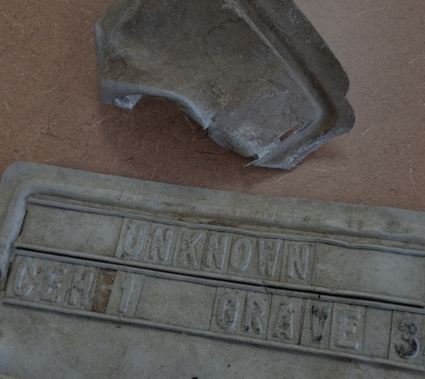
In an area on the southern end of Resthaven Cemetery, you will find the resting place of the majority of Laurel Lake relocated graves. Over the past 48 years, Resthaven has often neglected the area. Only recently have historians taken an interest in bringing some dignity back to the graves there. The Corps of Engineers had provided small concrete markers with metal nameplates on them for all those who had only fieldstones in the original cemetery. The nameplates (most say "unknown") are similar to the temporary markers used by funeral homes, and they have not stood the test of time very well. Nor have the concrete markers - each measuring 8 by 10 by 16 inches. The markers have settled into the ground and many are now invisible, although I have been trying to raise some of them in the past couple of years. Out of 320 individuals who moved, only 116 were known names, while 204 individuals were unknown names with only field stones as markers. 178 of those who moved to Resthaven are unknowns.
The original locations of the cemeteries were situated among the oldest settlement locations in the area. These communities dated back to Laurel and Whitley Counties' earliest settlements - families who settled along the Laurel River basin, who farmed and lived off the land. Such a high number of unknown graves and field stones is an indication of burials dating back to the early 1800s, possibly 1780s and 1790s. It is not a far stretch to conclude that some of these individuals traveled Boone Trace in the 1770s through the 1790s, followed Laurel River to the south, and settled an area close to the mouth of Laurel near the Cumberland River - an area rich in fertile soil and water resources.
The removal of old graves is not a task for the faint of heart. Finding older graves such as these was often a guessing game. Following depressions in the soil, or an area beneath an old field stone is not an exact science. Older graves rarely contain anything close to what we imagine - no skeletal remains, no coffins - only a keen eye would notice a change in the color of dirt, possible leather items, or other personal effects. Best guesses were the rule for equipment operators who would scoop up whatever remains were there and deposit the dirt into wooden boxes that were provided by the contractor.
In the end, Resthaven Cemetery received 288 of the relocated graves. Other cemeteries in the area that were selected by the next of kin include Wigginton, Corinth, Locust Grove, Alsip, Wells, Whittaker, Prewitt, Dorthae Martin, Dryden-Walters and Mt. Victory.
The cemeteries in the original Corps of Engineers Report and their fate are:
1. Poynter - Located in an area between Sam Branch and Good Branch near
Craig's Creek Road. 89 graves were moved. The location of the cemetery was not inundated by water.
2. Clark Thompson - Located near the mouth of Marsh Branch. 8 graves moved.
3. Roger's Ford - Located about 200 feet off of Flatwoods boat ramp. 133 graves moved.
4. Williams - Located a short distance south of Flatwoods boat ramp. Contained only one grave of Speed Williams who always wanted to be buried in the field in front of his home.
5. Micer - Not moved. Located near Whitman's Branch shooting range. Efforts to find Mincer have not been successful.
6. Rogers - Located along the river, on the Whitley County side and about 800 feet from Rodgers Ford Cemetery. 25 graves moved. 22 to Resthaven.
7. Legal - Located upriver from Flatwoods boat ramp at the mouth of Rogers Creek. Legal also had a school/church house. 30 graves moved.
8. Vogel - Located on the property of what is now Laurel River Baptist Camp. 3 graves moved.
9. Delph - Located in Whitley County near Walker Branch off Bee Creek Road. The cemetery was not inundated by water. 29 graves were moved.
10. Sears - Not Moved. Located in Whitley County off Bee Creek road in the forest approximately 0.7 mile from the spillway.
11. Earls - Not Moved. Located on the cliff above Whippoorwill Creek. Contains the single grave of Jim Earls.
12. Hensley - Located near Grove Marina road. The cemetery was not inundated by water. 2 graves were moved.
As of this writing, I am working with some others to obtain funding to restore the graves at Resthaven Cemetery. The project will involve locating each marker, raising each marker, providing a gravel base to prevent sinking, applying new name/identification plates to each marker, and adding a historic kiosk for visitors to understand the significance of the burials there. Anyone interested in participating in this effort, please contact me at: doug3959@yahoo.com.
Douglas Phelps is a local cemetery volunteer and historian.
" Attached photos are a sampling of the conditions of the Corps of Engineers grave markers that were placed at Resthaven Cemetery. The photos demonstrate the sunken markers, some I have uncovered and the metal plates that were used in 1973."
- Doug Phelps